


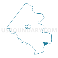
Westgate Voting District, Fairfax County, Virginia
About
Outline

Summary
| Unique Area Identifier | 681494 |
| Name | Westgate Voting District |
| County | Fairfax County |
| State | Virginia |
| Area (square miles) | 3.28 |
| Land Area (square miles) | 2.85 |
| Water Area (square miles) | 0.43 |
| % of Land Area | 86.94 |
| % of Water Area | 13.06 |
| Latitude of the Internal Point | 38.70816170 |
| Longtitude of the Internal Point | -77.10914060 |
Maps

Graphs
Select a template below for downloading or customizing gragh for Westgate Voting District, Fairfax County, Virginia


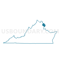
Neighbors
Neighoring Voting District (by Name) Neighboring Voting District on the Map
- Belvoir Voting District, Fairfax County, VA
- Fort Hunt Voting District, Fairfax County, VA
- Gunston Voting District, Fairfax County, VA
- Prince George's Precinct 05-007, Prince George's County, MD
- Voting Districts not defined, Charles County, MD
- Whitman Voting District, Fairfax County, VA
- Woodlawn Voting District, Fairfax County, VA
- Woodley Voting District, Fairfax County, VA
Top 10 Neighboring County Subdivision (by Population) Neighboring County Subdivision on the Map
- Lee district, Fairfax County, VA (128,453)
- Mount Vernon district, Fairfax County, VA (106,296)
- District 5, Piscataway, Prince George's County, MD (37,579)
- District 7, Pomonkey, Charles County, MD (13,934)
Top 10 Neighboring Place (by Population) Neighboring Place on the Map
- Woodlawn CDP, VA (20,804)
- Fort Hunt CDP, VA (16,045)
- Mount Vernon CDP, VA (12,416)
- Fort Belvoir CDP, VA (7,100)
Top 10 Neighboring Unified School District (by Population) Neighboring Unified School District on the Map
- Fairfax County Public Schools, VA (1,081,726)
- Prince George's County Public Schools, MD (863,420)
- Charles County Public Schools, MD (146,551)
Top 10 Neighboring State Legislative District Lower Chamber (by Population) Neighboring State Legislative District Lower Chamber on the Map
- State House District 42, VA (81,840)
- State House District 44, VA (79,883)
- State House District 43, VA (78,088)
- State House Districts not defined (Prince George's County), MD (0)
- State House Districts not defined (Charles County), MD (0)
Top 10 Neighboring State Legislative District Upper Chamber (by Population) Neighboring State Legislative District Upper Chamber on the Map
- State Senate District 36, VA (219,048)
- State Senate Districts not defined (Prince George's County), MD (0)
- State Senate Districts not defined (Charles County), MD (0)
Top 10 Neighboring 111th Congressional District (by Population) Neighboring 111th Congressional District on the Map
Top 10 Neighboring Census Tract (by Population) Neighboring Census Tract on the Map
- Census Tract 4218, Fairfax County, VA (5,862)
- Census Tract 4160, Fairfax County, VA (5,522)
- Census Tract 4162, Fairfax County, VA (5,280)
- Census Tract 4158, Fairfax County, VA (4,752)
- Census Tract 4161, Fairfax County, VA (3,734)
- Census Tract 8013.09, Prince George's County, MD (3,408)
- Census Tract 4159, Fairfax County, VA (3,160)
- Census Tract 4219, Fairfax County, VA (2,216)
- Census Tract 9900, Charles County, MD (0)